
Topografische kaart Lexington Hills
Interactieve kaart
Klik op de kaart om de hoogte weer te geven.
Over deze kaart
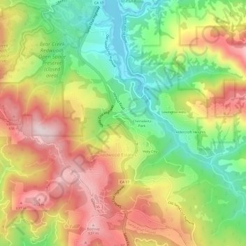
Naam: Topografische kaart Lexington Hills, hoogte, reliëf.
Gemiddelde hoogte: 424 m
Minimale hoogte: 180 m
Maximale hoogte: 687 m
Andere topografische kaarten
Klik op een kaart om zijn topografie, zijn hoogte en zijn reliëf te bekijken.
Chemeketa Park
United States > California > Santa Clara County > Redwood Estates
Chemeketa Park, Redwood Estates, Santa Clara County, California, 95033, United States
Gemiddelde hoogte: 413 m
Holy City
United States > California > Santa Clara County > Redwood Estates
Holy City, Redwood Estates, Santa Clara County, California, 95033, United States
Gemiddelde hoogte: 429 m
Lexington Hills
United States > California > Santa Clara County > Redwood Estates > Lexington Hills
Lexington Hills, Redwood Estates, Santa Clara County, California, 95044, United States
Gemiddelde hoogte: 406 m