
Topografische kaart Chandalar Shelf
Interactieve kaart
Klik op de kaart om de hoogte weer te geven.
Over deze kaart
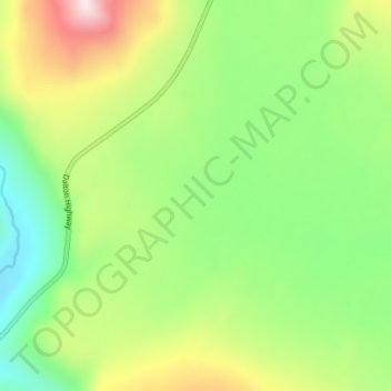
Naam: Topografische kaart Chandalar Shelf, hoogte, reliëf.
Locatie: Chandalar Shelf, North Slope, Alaska, United States (68.04606 -149.60866 68.04616 -149.60856)
Gemiddelde hoogte: 974 m
Minimale hoogte: 791 m
Maximale hoogte: 1.280 m
Andere topografische kaarten
Klik op een kaart om zijn topografie, zijn hoogte en zijn reliëf te bekijken.
Prudhoe Bay
United States > Alaska > North Slope
Prudhoe Bay, North Slope, Alaska, 99734, United States
Gemiddelde hoogte: 10 m
Toolik Field Station
United States > Alaska > North Slope
Toolik Field Station, North Slope, Alaska, United States
Gemiddelde hoogte: 740 m
Toolik River
United States > Alaska > North Slope
Toolik River, North Slope, Alaska, United States
Gemiddelde hoogte: 126 m
Kaktovik
United States > Alaska > North Slope > Kaktovik
Kaktovik, North Slope, Alaska, 99747, United States
Gemiddelde hoogte: 5 m
Point Barrow
United States > Alaska > North Slope
Point Barrow, North Slope, Alaska, United States
Gemiddelde hoogte: 0 m
Deadhorse
United States > Alaska > North Slope
Deadhorse, North Slope, Alaska, 99734, United States
Gemiddelde hoogte: 14 m
Utqiaġvik
United States > Alaska > North Slope
Utqiaġvik, North Slope, Alaska, 99273, United States
Gemiddelde hoogte: 4 m