
Topografische kaart Wasaga Beach Provincial Park
Interactieve kaart
Klik op de kaart om de hoogte weer te geven.
Over deze kaart
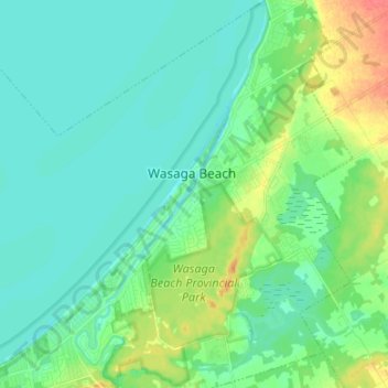
Naam: Topografische kaart Wasaga Beach Provincial Park, hoogte, reliëf.
Gemiddelde hoogte: 185 m
Minimale hoogte: 172 m
Maximale hoogte: 222 m
The Town of Wasaga Beach covers an area of 61.13 square kilometres (23.60 sq mi) comprised predominantly of sand and loamy sand that exhibit excessive to good drainage and irregular to moderately sloping topography. The poor soil quality makes it difficult to sustain lush lawns in the town. The Canada Land Inventory for Agriculture rates the lands as predominately Class Six and Seven with primary restrictions of adverse topography, erosion damage and low natural fertility.
Andere topografische kaarten
Klik op een kaart om zijn topografie, zijn hoogte en zijn reliëf te bekijken.
Wasaga Beach Provincial Park
Canada > Ontario > Simcoe County > Wasaga Beach
Wasaga Beach Provincial Park, Wasaga Beach, Simcoe County, Central Ontario, Ontario, Canada
Gemiddelde hoogte: 188 m
Springhurst Beach
Canada > Ontario > Simcoe County > Wasaga Beach > Springhurst Beach
Springhurst Beach, Wasaga Beach, Simcoe County, Central Ontario, Ontario, L0L 2P0, Canada
Gemiddelde hoogte: 184 m