
Topografische kaart Tiffield
Klik op de kaart om de hoogte weer te geven.
Over deze kaart
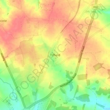
Naam: Topografische kaart Tiffield, hoogte, reliëf.
Gemiddelde hoogte: 122 m
Minimale hoogte: 86 m
Maximale hoogte: 149 m
Andere topografische kaarten
Klik op een kaart om zijn topografie, zijn hoogte en zijn reliëf te bekijken.
Northampton
United Kingdom > England > West Northamptonshire
As with the rest of the British Isles, Northampton experiences an oceanic climate with cool summers and mild winters. The official Met Office weather station for Northampton is the Moulton Park Weather Station at the University of Northampton. Situated at an elevation of around 130 m (427 ft) above sea level…
Gemiddelde hoogte: 89 m
Northampton
United Kingdom > England > West Northamptonshire > Northampton
As with the rest of the British Isles, Northampton experiences a maritime climate with cool summers and mild winters. The official Met Office weather station for Northampton is the Moulton Park Weather Station at the University of Northampton. Situated at an elevation of around 130 m (427 ft) above sea level…
Gemiddelde hoogte: 89 m
Daventry
United Kingdom > England > West Northamptonshire
According to local folklore Daventry had Danish (Viking) origins, this was partly due to the old pronunciation of Daventry as Daintry, which was interpreted as "Dane Tree", however in more modern interpretation the town's name is thought likelier to be Anglo-Saxon in origin: "Dafa's tree" (Dafa being a…
Gemiddelde hoogte: 148 m
Preston Capes
United Kingdom > England > West Northamptonshire > Preston Capes
Gemiddelde hoogte: 156 m
Towcester
United Kingdom > England > West Northamptonshire
St. Lawrence's C of E Church, stands in the middle of the town. It has a 12th-century Norman transitional ground plan and foundation, probably laid over a Saxon 10th century stone building. Its ecclesiastical heritage may well relate back to Roman times as St Lawrence was patron saint of the Roman legions. The…
Gemiddelde hoogte: 108 m
Ravensthorpe Reservoir
United Kingdom > England > West Northamptonshire > Coton
Gemiddelde hoogte: 131 m
Brafield on the Green
United Kingdom > England > West Northamptonshire > Brafield-on-the-Green
Gemiddelde hoogte: 92 m