
Topografische kaart Lake McDonald
Interactieve kaart
Klik op de kaart om de hoogte weer te geven.
Over deze kaart
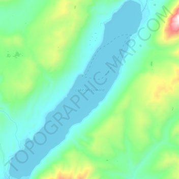
Naam: Topografische kaart Lake McDonald, hoogte, reliëf.
Locatie: Lake McDonald, Flathead County, Montana, United States (48.52745 -113.99626 48.64055 -113.86895)
Gemiddelde hoogte: 1.209 m
Minimale hoogte: 954 m
Maximale hoogte: 2.265 m
Lake McDonald is the largest lake in Glacier National Park. It is located at 48°35′N 113°55′W / 48.583°N 113.917°W / 48.583; -113.917 in Flathead County in the U.S. state of Montana. Lake McDonald is approximately 10 miles (16 km) long, and over a mile (1.6 km) wide and 472 feet (130 m) deep, filling a valley formed by a combination of erosion and glacial activity. Lake McDonald lies at an elevation of 3,153 feet (961 m) and is on the west side of the Continental Divide. Going-to-the-Sun Road parallels the lake along its southern shoreline. The surface area of the lake is 6,823 acres (27.6 km2).
Andere topografische kaarten
Klik op een kaart om zijn topografie, zijn hoogte en zijn reliëf te bekijken.
Tunnel Creek
United States > Montana > Flathead County
Tunnel Creek, Flathead County, Montana, United States
Gemiddelde hoogte: 1.211 m
Kalispell
United States > Montana > Flathead County
Kalispell, Flathead County, Montana, United States
Gemiddelde hoogte: 934 m
West Glacier
United States > Montana > Flathead County > West Glacier
West Glacier, Flathead County, Montana, 59936, United States
Gemiddelde hoogte: 1.201 m