
Topografische kaart Valley Creek Junction
Interactieve kaart
Klik op de kaart om de hoogte weer te geven.
Over deze kaart
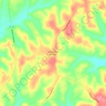
Naam: Topografische kaart Valley Creek Junction, hoogte, reliëf.
Locatie: Valley Creek Junction, Dallas County, Alabama, United States (32.54847 -86.96888 32.58847 -86.92888)
Gemiddelde hoogte: 115 m
Minimale hoogte: 70 m
Maximale hoogte: 157 m
Andere topografische kaarten
Klik op een kaart om zijn topografie, zijn hoogte en zijn reliëf te bekijken.
Selmont–West Selmont
United States > Alabama > Dallas County
Selmont–West Selmont, Dallas County, Alabama, 36702, United States
Gemiddelde hoogte: 35 m
Elm Bluff
United States > Alabama > Dallas County
Elm Bluff, Dallas County, Alabama, United States
Gemiddelde hoogte: 88 m
Plantersville
United States > Alabama > Dallas County
Plantersville, Dallas County, Alabama, 36758, United States
Gemiddelde hoogte: 89 m
Orrville
United States > Alabama > Dallas County > Orrville
Orrville, Dallas County, Alabama, United States
Gemiddelde hoogte: 57 m
Valley Grande
United States > Alabama > Dallas County > Valley Grande
Valley Grande, Dallas County, Alabama, United States
Gemiddelde hoogte: 101 m
Sunset Mill Village
United States > Alabama > Dallas County > Selma > Sunset Mill Village
Sunset Mill Village, Selma, Dallas County, Alabama, 36701, United States
Gemiddelde hoogte: 38 m