
Topografische kaart Montfort
Interactieve kaart
Klik op de kaart om de hoogte weer te geven.
Over deze kaart
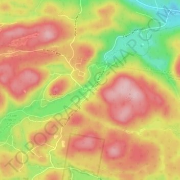
Naam: Topografische kaart Montfort, hoogte, reliëf.
Gemiddelde hoogte: 422 m
Minimale hoogte: 301 m
Maximale hoogte: 503 m
Andere topografische kaarten
Klik op een kaart om zijn topografie, zijn hoogte en zijn reliëf te bekijken.
Lac Windish
Canada > Quebec > Les Pays-d'en-Haut > Wentworth-Nord
Lac Windish, Wentworth-Nord, Les Pays-d'en-Haut, Laurentides, Quebec, Canada
Gemiddelde hoogte: 303 m
Lac Wentworth
Canada > Quebec > Les Pays-d'en-Haut > Wentworth-Nord
Lac Wentworth, Wentworth-Nord, Les Pays-d'en-Haut, Laurentides, Quebec, Canada
Gemiddelde hoogte: 343 m
Lac Lafantaisie
Canada > Quebec > Les Pays-d'en-Haut > Wentworth-Nord
Lac Lafantaisie, Wentworth-Nord, Les Pays-d'en-Haut, Laurentides, Quebec, Canada
Gemiddelde hoogte: 330 m