
Topografische kaart Carlisle County
Interactieve kaart
Klik op de kaart om de hoogte weer te geven.
Over deze kaart
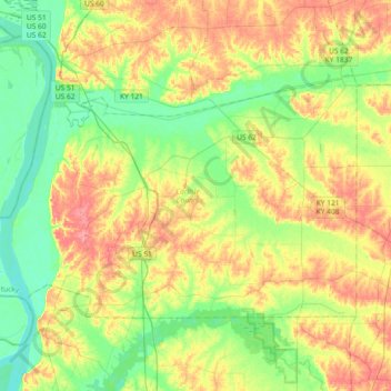
Naam: Topografische kaart Carlisle County, hoogte, reliëf.
Locatie: Carlisle County, Kentucky, United States (36.77163 -89.17923 36.95466 -88.81269)
Gemiddelde hoogte: 118 m
Minimale hoogte: 83 m
Maximale hoogte: 168 m
Andere topografische kaarten
Klik op een kaart om zijn topografie, zijn hoogte en zijn reliëf te bekijken.
Princeton
United States > Kentucky > Caldwell County
Princeton, Caldwell County, Kentucky, United States
Gemiddelde hoogte: 155 m
McCracken County
McCracken County, Kentucky, United States
Gemiddelde hoogte: 119 m
Freeburn
United States > Kentucky > Pike County
Freeburn, Pike County, Kentucky, 41528, United States
Gemiddelde hoogte: 342 m
Simpson County
Simpson County, Kentucky, United States
Gemiddelde hoogte: 204 m
Elliott County
Elliott County, Kentucky, United States
Gemiddelde hoogte: 278 m
Trixie
United States > Kentucky > Clay County
Trixie, Clay County, Kentucky, United States
Gemiddelde hoogte: 294 m
Kenwood
United States > Kentucky > Jefferson County > Louisville
Kenwood, Louisville, Jefferson County, Kentucky, 40214, United States
Gemiddelde hoogte: 153 m
Riverview
United States > Kentucky > Greenup County > Russell
Riverview, Russell, Greenup County, Kentucky, 45638, United States
Gemiddelde hoogte: 182 m
Winchester
United States > Kentucky > Clark County
Winchester, Clark County, Kentucky, United States
Gemiddelde hoogte: 296 m
Fords Creek
United States > Kentucky > Trigg County
Fords Creek, Trigg County, Kentucky, United States
Gemiddelde hoogte: 135 m
Greendale
United States > Kentucky > Fayette County > Lexington
Greendale, Lexington, Fayette County, Kentucky, 40511, United States
Gemiddelde hoogte: 284 m
Finney
United States > Kentucky > Barren County
Finney, Barren County, Kentucky, United States
Gemiddelde hoogte: 187 m
Ballard County
Ballard County, Kentucky, United States
Gemiddelde hoogte: 113 m
Christian County
Christian County, Kentucky, United States
Gemiddelde hoogte: 171 m
Smiths Creek
United States > Kentucky > Carter County
Smiths Creek, Carter County, Kentucky, 41128, United States
Gemiddelde hoogte: 313 m
Glenview
United States > Kentucky > Jefferson County
Glenview, Jefferson County, Kentucky, 40025, United States
Gemiddelde hoogte: 155 m
Newport
United States > Kentucky > Campbell County
Newport, Campbell County, Kentucky, 41071, United States
Gemiddelde hoogte: 173 m
Roberts Bluff
United States > Kentucky > Hopkins County
Roberts Bluff, Hopkins County, Kentucky, United States
Gemiddelde hoogte: 121 m
Russell County
Russell County, Kentucky, United States
Gemiddelde hoogte: 281 m
Coal Cliff
United States > Kentucky > Wayne County
Coal Cliff, Wayne County, Kentucky, United States
Gemiddelde hoogte: 313 m
La Grange
United States > Kentucky > Oldham County
La Grange, Oldham County, Kentucky, 40031, United States
Gemiddelde hoogte: 246 m
Shetland
United States > Kentucky > Woodford County
Shetland, Woodford County, Kentucky, 40383, United States
Gemiddelde hoogte: 284 m
Paducah
United States > Kentucky > McCracken County
Paducah, McCracken County, Kentucky, United States
Gemiddelde hoogte: 108 m
Campbell County
Campbell County, Kentucky, United States
Gemiddelde hoogte: 223 m
Shelbyville
United States > Kentucky > Shelby County
Shelbyville, Shelby County, Kentucky, 40065, United States
Gemiddelde hoogte: 232 m
Williamstown
United States > Kentucky > Grant County
Williamstown, Grant County, Kentucky, 41097, United States
Gemiddelde hoogte: 262 m
Northern
United States > Kentucky > Floyd County > Northern
Northern, Floyd County, Kentucky, 41622, United States
Gemiddelde hoogte: 285 m
Robinson Creek
United States > Kentucky > Pike County > Robinson Creek
Robinson Creek, Pike County, Kentucky, 41560, United States
Gemiddelde hoogte: 337 m
Hammonville
United States > Kentucky > Hart County > Hammonville
Hammonville, Hart County, Kentucky, United States
Gemiddelde hoogte: 232 m
Calloway County
United States > Kentucky > Calloway County
Calloway County, Kentucky, United States
Gemiddelde hoogte: 150 m
Charters
United States > Kentucky > Lewis County > Charters
Charters, Lewis County, Kentucky, United States
Gemiddelde hoogte: 238 m
Clarkson
United States > Kentucky > Grayson County > Clarkson
Clarkson, Grayson County, Kentucky, United States
Gemiddelde hoogte: 212 m
Bullitt County
Bullitt County, Kentucky, United States
Gemiddelde hoogte: 183 m
Marshall County
United States > Kentucky > Marshall County
Marshall County, Kentucky, United States
Gemiddelde hoogte: 126 m
Bighill
United States > Kentucky > Madison County > Bighill
Bighill, Madison County, Kentucky, United States
Gemiddelde hoogte: 297 m
Victoria
United States > Kentucky > Hopkins County > Madisonville > Victoria
Victoria, Madisonville, Hopkins County, Kentucky, 42431, United States
Gemiddelde hoogte: 140 m
Mayfield
United States > Kentucky > Graves County > Mayfield > Mayfield
Mayfield, Graves County, Kentucky, 42066, United States
Gemiddelde hoogte: 148 m
Oakdale
United States > Kentucky > Jefferson County > Louisville > Oakdale
Oakdale, Louisville, Jefferson County, Kentucky, 40215, United States
Gemiddelde hoogte: 143 m
Mayfield
United States > Kentucky > Graves County
Mayfield, Graves County, Kentucky, 42066, United States
Gemiddelde hoogte: 145 m
Jeff
United States > Kentucky > Perry County > Jeff
Jeff, Perry County, Kentucky, 41751, United States
Gemiddelde hoogte: 374 m
Prospect
United States > Kentucky > Jefferson County
Prospect, Jefferson County, Kentucky, United States
Gemiddelde hoogte: 166 m
Prestonville
United States > Kentucky > Carroll County > Prestonville
Prestonville, Carroll County, Kentucky, United States
Gemiddelde hoogte: 151 m
Mammoth Cave National Park
United States > Kentucky > Edmonson County > Brownsville
Mammoth Cave National Park, Brownsville, Edmonson County, Kentucky, United States
Gemiddelde hoogte: 215 m
Glen Springs
United States > Kentucky > Glen Springs
Glen Springs, Lewis County, Kentucky, United States
Gemiddelde hoogte: 287 m
Jameison Hill
Jameison Hill, Livingston County, Kentucky, 42081, United States
Gemiddelde hoogte: 161 m
Lucas
United States > Kentucky > Lucas
Lucas, Barren County, Kentucky, 42156, United States
Gemiddelde hoogte: 197 m