
Topografische kaart Boulder Creek
Interactieve kaart
Klik op de kaart om de hoogte weer te geven.
Over deze kaart
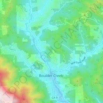
Naam: Topografische kaart Boulder Creek, hoogte, reliëf.
Gemiddelde hoogte: 287 m
Minimale hoogte: 136 m
Maximale hoogte: 799 m
Boulder Creek sits at the north end of the San Lorenzo Valley at the confluence of San Lorenzo River and Boulder Creek within the Santa Cruz Mountains, a Level IV ecoregion designated by the United States Environmental Protection Agency (EPA), an area surrounded by steep, redwood- and pine- covered hills formed by the river, creek, and their tributaries. The river flows through Boulder Creek on the east and south through Brookdale, Ben Lomond, and Felton, and continues south to the City of Santa Cruz where it enters Monterey Bay. Directly across from Boulder Creek's confluence with the San Lorenzo River, Bear Creek flows into the river and creates a topographical feature known as the Turkey Foot. The Turkey Foot creates a floodplain, particularly on the western side of the river where the mountainside is less steep.
Andere topografische kaarten
Klik op een kaart om zijn topografie, zijn hoogte en zijn reliëf te bekijken.
Huckleberry Woods
United States > California > Santa Cruz County > Boulder Creek
Huckleberry Woods, Boulder Creek, Santa Cruz County, California, 95006, United States
Gemiddelde hoogte: 263 m