
Topografische kaart Château-Renault
Interactieve kaart
Klik op de kaart om de hoogte weer te geven.
Over deze kaart
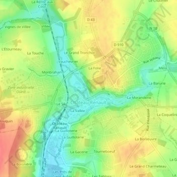
Naam: Topografische kaart Château-Renault, hoogte, reliëf.
Gemiddelde hoogte: 112 m
Minimale hoogte: 83 m
Maximale hoogte: 141 m
Château-Renault is located on the Far-West of the Gâtine Tourangelle plateau, next to the Loir-et-Cher department and at the confluence of two rivers. The Gault and the Brenne. Its Elevation vary between 90 meters and 140 meters on the plateau. The area of the commune is 3.51 square kilometre.