
Topografische kaart Chihuahua City
Interactieve kaart
Klik op de kaart om de hoogte weer te geven.
Chihuahua City
Chihuahua lies on the western side of the Chihuahuan Desert ecoregion and as such has a semiarid climate (Köppen climate classification BSh). However, it is not as hot as most of the lower elevated portions of the desert to the east owing to an altitude of almost 1,500 metres (4,900 feet) above sea level.
Over deze kaart
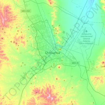
Naam: Topografische kaart Chihuahua City, hoogte, reliëf.
Gemiddelde hoogte: 1.555 m
Minimale hoogte: 1.295 m
Maximale hoogte: 2.245 m