
Doe een donatie
Rust jezelf uit voor je volgende avontuur:
Als Amazon-partner verdient deze site een commissie op in aanmerking komende aankopen, zonder extra kosten voor jou.
Topografische kaart Villedieu-les-Poêles-Rouffigny
Klik op de kaart om de hoogte weer te geven.
Doe een donatie
Rust jezelf uit voor je volgende avontuur:
Als Amazon-partner verdient deze site een commissie op in aanmerking komende aankopen, zonder extra kosten voor jou.
Villedieu-les-Poêles-Rouffigny
En 2010, le climat de la commune est de type climat océanique franc, selon une étude du CNRS s'appuyant sur une série de données couvrant la période 1971-2000. En 2020, Météo-France publie une typologie des climats de la France métropolitaine dans laquelle la commune est exposée à un climat océanique et est dans la région climatique Normandie (Cotentin, Orne), caractérisée par une pluviométrie relativement élevée (850 mm/a) et un été frais (15,5 °C) et venté. Parallèlement le GIEC normand, un groupe régional d’experts sur le climat, différencie quant à lui, dans une étude de 2020, trois grands types de climats pour la région Normandie, nuancés à une échelle plus fine par les facteurs géographiques locaux. La commune est, selon ce zonage, exposée à un « climat contrasté des collines », correspondant au Bocage normand, bien arrosé, voire très arrosé sur les reliefs les plus exposés au flux d’ouest, et frais en raison de l’altitude.
Doe een donatie
Rust jezelf uit voor je volgende avontuur:
Als Amazon-partner verdient deze site een commissie op in aanmerking komende aankopen, zonder extra kosten voor jou.
Over deze kaart
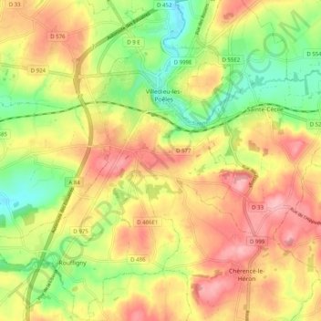
Naam: Topografische kaart Villedieu-les-Poêles-Rouffigny, hoogte, reliëf.
Gemiddelde hoogte: 166 m
Minimale hoogte: 99 m
Maximale hoogte: 226 m
Doe een donatie
Rust jezelf uit voor je volgende avontuur:
Als Amazon-partner verdient deze site een commissie op in aanmerking komende aankopen, zonder extra kosten voor jou.
Andere topografische kaarten
Klik op een kaart om zijn topografie, zijn hoogte en zijn reliëf te bekijken.
Mont Castre
France > Normandie > Manche > Le Plessis-Lastelle
Le mont Castre, appelé aussi mont Castré, est une montagne du Massif armoricain. Elle est située dans le département de la Manche, sur les communes de Lithaire, du Plessis-Lastelle et de Gerville-la-Forêt. Il culmine à 130 m d'altitude. Chargé d'histoire, on y trouve des vestiges allant de la…
Gemiddelde hoogte: 69 m
Doe een donatie
Rust jezelf uit voor je volgende avontuur:
Als Amazon-partner verdient deze site een commissie op in aanmerking komende aankopen, zonder extra kosten voor jou.
Mont Saint-Michel
France > Normandie > Manche > Le Mont-Saint-Michel
Le mont baigne dans la baie du Mont-Saint-Michel, ouverte sur la Manche et s’élève dans une grande plaine sablonneuse. L’îlot atteint 92 mètres d’altitude et offre une superficie émergée d’environ 7 ha, la partie essentielle du rocher étant couverte par l’emprise au sol de l’abbaye du…
Gemiddelde hoogte: 2 m
Doe een donatie
Rust jezelf uit voor je volgende avontuur:
Als Amazon-partner verdient deze site een commissie op in aanmerking komende aankopen, zonder extra kosten voor jou.
La Maison Vard
France > Normandie > Manche > Saint-Sauveur-Villages > Vaudrimesnil
Gemiddelde hoogte: 36 m
Doe een donatie
Rust jezelf uit voor je volgende avontuur:
Als Amazon-partner verdient deze site een commissie op in aanmerking komende aankopen, zonder extra kosten voor jou.
Doe een donatie
Rust jezelf uit voor je volgende avontuur:
Als Amazon-partner verdient deze site een commissie op in aanmerking komende aankopen, zonder extra kosten voor jou.
Doe een donatie
Rust jezelf uit voor je volgende avontuur:
Als Amazon-partner verdient deze site een commissie op in aanmerking komende aankopen, zonder extra kosten voor jou.
Doe een donatie
Rust jezelf uit voor je volgende avontuur:
Als Amazon-partner verdient deze site een commissie op in aanmerking komende aankopen, zonder extra kosten voor jou.
Huanville
France > Normandie > Manche > Port-Bail-sur-Mer > Saint-Lô-d'Ourville
Gemiddelde hoogte: 30 m
Doe een donatie
Rust jezelf uit voor je volgende avontuur:
Als Amazon-partner verdient deze site een commissie op in aanmerking komende aankopen, zonder extra kosten voor jou.
Doe een donatie
Rust jezelf uit voor je volgende avontuur:
Als Amazon-partner verdient deze site een commissie op in aanmerking komende aankopen, zonder extra kosten voor jou.
Doe een donatie
Rust jezelf uit voor je volgende avontuur:
Als Amazon-partner verdient deze site een commissie op in aanmerking komende aankopen, zonder extra kosten voor jou.
Doe een donatie
Rust jezelf uit voor je volgende avontuur:
Als Amazon-partner verdient deze site een commissie op in aanmerking komende aankopen, zonder extra kosten voor jou.
Doe een donatie
Rust jezelf uit voor je volgende avontuur:
Als Amazon-partner verdient deze site een commissie op in aanmerking komende aankopen, zonder extra kosten voor jou.
Doe een donatie
Rust jezelf uit voor je volgende avontuur:
Als Amazon-partner verdient deze site een commissie op in aanmerking komende aankopen, zonder extra kosten voor jou.
Doe een donatie
Rust jezelf uit voor je volgende avontuur:
Als Amazon-partner verdient deze site een commissie op in aanmerking komende aankopen, zonder extra kosten voor jou.
Doe een donatie
Rust jezelf uit voor je volgende avontuur:
Als Amazon-partner verdient deze site een commissie op in aanmerking komende aankopen, zonder extra kosten voor jou.
Doe een donatie
Rust jezelf uit voor je volgende avontuur:
Als Amazon-partner verdient deze site een commissie op in aanmerking komende aankopen, zonder extra kosten voor jou.
Doe een donatie
Rust jezelf uit voor je volgende avontuur:
Als Amazon-partner verdient deze site een commissie op in aanmerking komende aankopen, zonder extra kosten voor jou.
Doe een donatie
Rust jezelf uit voor je volgende avontuur:
Als Amazon-partner verdient deze site een commissie op in aanmerking komende aankopen, zonder extra kosten voor jou.
Hameau aux Mières
France > Normandie > Manche > La Hague > Omonville-la-Petite
Gemiddelde hoogte: 61 m
Doe een donatie
Rust jezelf uit voor je volgende avontuur:
Als Amazon-partner verdient deze site een commissie op in aanmerking komende aankopen, zonder extra kosten voor jou.
Doe een donatie
Rust jezelf uit voor je volgende avontuur:
Als Amazon-partner verdient deze site een commissie op in aanmerking komende aankopen, zonder extra kosten voor jou.
La Croix au Grand
France > Normandie > Manche > Villedieu-les-Poêles-Rouffigny > Villedieu-les-Poêles
Gemiddelde hoogte: 163 m
Doe een donatie
Rust jezelf uit voor je volgende avontuur:
Als Amazon-partner verdient deze site een commissie op in aanmerking komende aankopen, zonder extra kosten voor jou.
Sortosville-en-Beaumont
France > Normandie > Manche > Sortosville-en-Beaumont > Sortosville-en-Beaumont
Gemiddelde hoogte: 81 m
Saint-Georges-Montcocq
France > Normandie > Manche > Saint-Georges-Montcocq > Saint-Georges-Montcocq
Gemiddelde hoogte: 76 m
L'Étang-Bertrand
France > Normandie > Manche > L'Étang-Bertrand > L'Étang-Bertrand
Gemiddelde hoogte: 36 m
Doe een donatie
Rust jezelf uit voor je volgende avontuur:
Als Amazon-partner verdient deze site een commissie op in aanmerking komende aankopen, zonder extra kosten voor jou.
Doe een donatie
Rust jezelf uit voor je volgende avontuur:
Als Amazon-partner verdient deze site een commissie op in aanmerking komende aankopen, zonder extra kosten voor jou.
La Trouparderie
France > Normandie > Manche > Carentan-les-Marais > Saint-Hilaire-Petitville
Gemiddelde hoogte: 8 m
Doe een donatie
Rust jezelf uit voor je volgende avontuur:
Als Amazon-partner verdient deze site een commissie op in aanmerking komende aankopen, zonder extra kosten voor jou.
La Croix des Tondieres
France > Normandie > Manche > Percy-en-Normandie > Percy
Gemiddelde hoogte: 121 m
Doe een donatie
Rust jezelf uit voor je volgende avontuur:
Als Amazon-partner verdient deze site een commissie op in aanmerking komende aankopen, zonder extra kosten voor jou.
Saint-Symphorien-les-Buttes
France > Normandie > Manche > Saint-Amand-Villages
Gemiddelde hoogte: 166 m
Doe een donatie
Rust jezelf uit voor je volgende avontuur:
Als Amazon-partner verdient deze site een commissie op in aanmerking komende aankopen, zonder extra kosten voor jou.