
Topografische kaart Manhattan Island
Interactieve kaart
Klik op de kaart om de hoogte weer te geven.
Over deze kaart
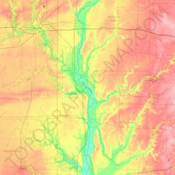
Naam: Topografische kaart Manhattan Island, hoogte, reliëf.
Gemiddelde hoogte: 201 m
Minimale hoogte: 137 m
Maximale hoogte: 266 m
Andere topografische kaarten
Klik op een kaart om zijn topografie, zijn hoogte en zijn reliëf te bekijken.
Glenns Valley
United States of America > Indiana > Indianapolis > Glenns Valley
Glenns Valley, Indianapolis, Marion, Indiana, 46217, United States of America
Gemiddelde hoogte: 211 m
Brendonwood
United States of America > Indiana > Indianapolis > Brendonwood
Brendonwood, Indianapolis, Marion, Indiana, 46226, United States of America
Gemiddelde hoogte: 248 m
Fiskville
United States of America > Indiana > Fiskville
Fiskville, Montgomery County, Indiana, 47933, United States of America
Gemiddelde hoogte: 230 m
Rob Roy
United States of America > Indiana > Rob Roy
Rob Roy, Fountain County, Indiana, United States of America
Gemiddelde hoogte: 197 m
Chandler
United States of America > Indiana > Chandler
Chandler, Pike County, Indiana, United States of America
Gemiddelde hoogte: 151 m
Blackford County
United States of America > Indiana
Blackford County, Indiana, United States of America
Gemiddelde hoogte: 274 m
Linville
United States of America > Indiana > Linville
Linville, Shelby County, Indiana, 46144, United States of America
Gemiddelde hoogte: 272 m
Kokomo
United States of America > Indiana > Kokomo
Kokomo, Howard County, Indiana, 46903, United States of America
Gemiddelde hoogte: 252 m
Mount Wells
United States of America > Indiana > Beverly Shores
Mount Wells, Beverly Shores, Porter County, Indiana, 46301, United States of America
Gemiddelde hoogte: 182 m