
Topografische kaart Tallahassee
Interactieve kaart
Klik op de kaart om de hoogte weer te geven.
Over deze kaart
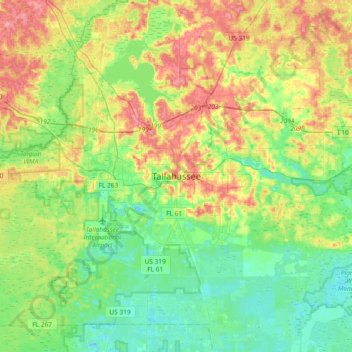
Naam: Topografische kaart Tallahassee, hoogte, reliëf.
Locatie: Tallahassee, Leon County, Florida, 32399-1300, United States (30.27808 -84.44093 30.59808 -84.12093)
Gemiddelde hoogte: 32 m
Minimale hoogte: 2 m
Maximale hoogte: 83 m
Tallahassee's terrain is hilly by Florida standards, being at the southern end of the Red Hills Region, just above the Cody Scarp. The elevation varies from near sea level to just over 200 feet (61 m), with the state capitol on one of the highest hills in the city. The city includes two large lake basins, Lake Jackson and Lake Lafayette, and borders the northern end of the Apalachicola National Forest.
Andere topografische kaarten
Klik op een kaart om zijn topografie, zijn hoogte en zijn reliëf te bekijken.
Saint Peter
United States > Florida > Leon County > Tallahassee
Saint Peter, Tallahassee, Leon County, Florida, 32308, United States
Gemiddelde hoogte: 49 m
Cascades Park
United States > Florida > Leon County > Tallahassee
Cascades Park, Tallahassee, Leon County, Florida, 32301, United States
Gemiddelde hoogte: 49 m
Four Points
United States > Florida > Leon County > Tallahassee
Four Points, Tallahassee, Leon County, Florida, 32313, United States
Gemiddelde hoogte: 24 m
Henrietta
United States > Florida > Leon County > Tallahassee > Henrietta
Henrietta, Tallahassee, Leon County, Florida, 32313, United States
Gemiddelde hoogte: 20 m