
Topografische kaart Wilmington
Interactieve kaart
Klik op de kaart om de hoogte weer te geven.
Over deze kaart
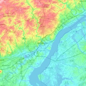
Naam: Topografische kaart Wilmington, hoogte, reliëf.
Gemiddelde hoogte: 43 m
Minimale hoogte: -5 m
Maximale hoogte: 170 m
On the western side of Market Street, the Piedmont topography is rocky and hilly, rising to a point that marks the watershed between the Brandywine River and the Christina River. This watershed line runs along Delaware Avenue westward from 10th Street and Market Street.
Andere topografische kaarten
Klik op een kaart om zijn topografie, zijn hoogte en zijn reliëf te bekijken.
Landlith
United States > Delaware > New Castle County > Wilmington
Landlith, Wilmington, New Castle County, Delaware, 19802, United States
Gemiddelde hoogte: 14 m
Rodney Square
United States > Delaware > New Castle County > Wilmington
Rodney Square, Rodney Square Historic District, Wilmington, New Castle County, Delaware, United States
Gemiddelde hoogte: 20 m
Wawaset Park
United States > Delaware > New Castle County > Wilmington
Wawaset Park, Wilmington, New Castle County, Delaware, 19806, United States
Gemiddelde hoogte: 48 m