
Topografische kaart Cherrapunji (Sohra)
Interactieve kaart
Klik op de kaart om de hoogte weer te geven.
Over deze kaart
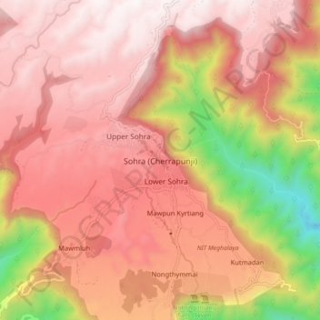
Naam: Topografische kaart Cherrapunji (Sohra), hoogte, reliëf.
Gemiddelde hoogte: 1.248 m
Minimale hoogte: 332 m
Maximale hoogte: 1.677 m
It has an average elevation of 1,430 metres (4,690 ft) and sits on a plateau in the southern part of the Khasi Hills, facing the plains of Bangladesh. The plateau rises 660 meters above the surrounding valleys.