
Topografische kaart Sunnyvale
Interactieve kaart
Klik op de kaart om de hoogte weer te geven.
Sunnyvale
According to the United States Census Bureau, the city has a total area of 22.7 sq mi (58.8 km2), of which, 22.0 sq mi (56.9 km2) of it is land and 0.69 sq mi (1.8 km2) of it (3.09%) is water. Its elevation is 130 feet above sea level.
Over deze kaart
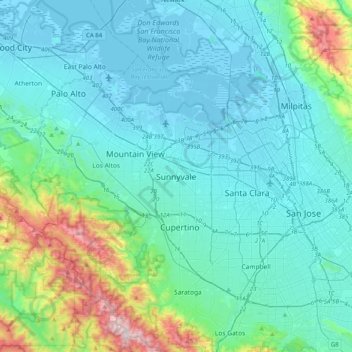
Naam: Topografische kaart Sunnyvale, hoogte, reliëf.
Gemiddelde hoogte: 150 m
Minimale hoogte: -6 m
Maximale hoogte: 980 m