
Topografische kaart Mahendragiri
Interactieve kaart
Klik op de kaart om de hoogte weer te geven.
Over deze kaart
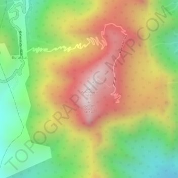
Naam: Topografische kaart Mahendragiri, hoogte, reliëf.
Gemiddelde hoogte: 1.108 m
Minimale hoogte: 711 m
Maximale hoogte: 1.494 m
Mahendragiri, is a mountain in Rayagada block of the district of Gajapati, Odisha, India. It is situated amongst the Eastern Ghats at an elevation of 1,501 metres (4,925 ft).It is second biodiversity Heritage Site of Odisha. This is considered as one out of Seven Kula Parvat of India.
Andere topografische kaarten
Klik op een kaart om zijn topografie, zijn hoogte en zijn reliëf te bekijken.
Eastern Ghats
India > Odisha > Ramagiri > Burakhat
Eastern Ghats, Burakhat, Ramagiri, Gajapati District, Odisha, India
Gemiddelde hoogte: 1.130 m