
Topografische kaart Norman
Interactieve kaart
Klik op de kaart om de hoogte weer te geven.
Over deze kaart
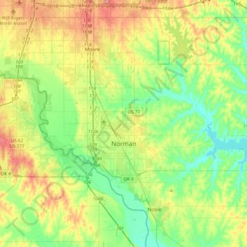
Naam: Topografische kaart Norman, hoogte, reliëf.
Locatie: Norman, Cleveland County, Oklahoma, United States (35.14532 -97.54745 35.34832 -97.17692)
Gemiddelde hoogte: 358 m
Minimale hoogte: 317 m
Maximale hoogte: 432 m
Norman and the surrounding areas are mostly flat with an elevation near 1,171 ft (357 m). The terrain in the western section of Norman is prairie, while the eastern section, including the area surrounding Lake Thunderbird, consists of some 6,000 acres (24 km2) of lakes and Cross Timbers forest. The lowest point within city limits is approximately 970 ft (296 m) above sea level (located at 35.20388N, 97.17735W). The highest point is approximately 1,245 ft (379 m) above sea level (located at 35.21266N, 97.39000W).
Andere topografische kaarten
Klik op een kaart om zijn topografie, zijn hoogte en zijn reliëf te bekijken.
Tom London Dam
United States > Oklahoma > Cleveland County
Tom London Dam, Cleveland County, Oklahoma, United States
Gemiddelde hoogte: 324 m
Little Axe
United States > Oklahoma > Cleveland County > Norman
Little Axe, Norman, Cleveland County, Oklahoma, United States
Gemiddelde hoogte: 321 m
Norman
United States > Oklahoma > Cleveland County > Norman
Norman, Cleveland County, Oklahoma, 73069, United States
Gemiddelde hoogte: 356 m
Moore
United States > Oklahoma > Cleveland County > Moore > Moore
Moore, Cleveland County, Oklahoma, 73160, United States
Gemiddelde hoogte: 377 m