
Topografische kaart Shangqiu
Interactieve kaart
Klik op de kaart om de hoogte weer te geven.
Over deze kaart
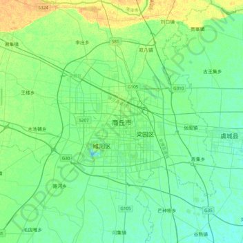
Naam: Topografische kaart Shangqiu, hoogte, reliëf.
Locatie: Shangqiu, Liangyuan District, Shangqiu City, Henan, China (34.25710 115.49086 34.57710 115.81086)
Gemiddelde hoogte: 51 m
Minimale hoogte: 44 m
Maximale hoogte: 67 m
Shangqiu is the easternmost prefecture of Henan province. Its administrative area ranges in longitude from 114 °49′ E to 116° 39′ E and in latitude from 33° 43′ N to 34° 52′ N, covering 10,704 square kilometres (4,133 sq mi). The city lies on the North China Plain and is mostly flat, with elevations ranging from 30 to 70 metres (98 to 230 ft), though the northwest part of the prefecture is more elevated than the southeast.
Andere topografische kaarten
Klik op een kaart om zijn topografie, zijn hoogte en zijn reliëf te bekijken.
Suiyang District
Suiyang District, Shangqiu, Henan, China
Gemiddelde hoogte: 48 m