
Topografische kaart Church Crookham
Interactieve kaart
Klik op de kaart om de hoogte weer te geven.
Over deze kaart
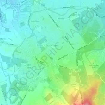
Naam: Topografische kaart Church Crookham, hoogte, reliëf.
Gemiddelde hoogte: 92 m
Minimale hoogte: 66 m
Maximale hoogte: 166 m
The parent sprawling parish of Crondall (in Crondall Hundred) was mostly rural at this time, with the 1831 edition of Samuel Lewis's Topographical Dictionary of England, which used the census returns to assess that Crookham had 623 inhabitants and not even mentioning the (at the time) much smaller Fleet. Other than Crondall tithing, this parish in 1800 consisted of four other tithings, Crookham (otherwise Church Crookham), Ewshot, Swanthorpe, and portions of Dippenhall (partly in Surrey, in Farnham Hundred). The soil is sandy here and in Ewshot, but is chalky in Swanthorpe and has some clay in other tithings.
Andere topografische kaarten
Klik op een kaart om zijn topografie, zijn hoogte en zijn reliëf te bekijken.
Brookly Stream
United Kingdom > England > Hampshire > Hart > Fleet
Brookly Stream, Fleet, Hart, Hampshire, South East England, England, GU51 3RF, United Kingdom
Gemiddelde hoogte: 78 m