
Topografische kaart Redhill
Klik op de kaart om de hoogte weer te geven.
Redhill
To the north, the town joins with the village of Merstham, north of which there is a "wind gap" in the chalk hills of the North Downs, at an elevation of 120 metres (390 ft) above sea level, through which the A23 road heads in from London. Geologists have speculated that there may once have been a consequent-flowing river, flowing northwards from the centre of the Weald-Artois Anticline and towards the River Thames, which originally cut both the Redhill Gap in the Greensand Ridge and the Merstham Gap in the chalk hills of the North Downs, before its waters were caught by subsequent streams of the River Mole (which itself cuts gaps northwards through the ridge at Betchworth, and through the Downs at Dorking, on its way to the Thames). Today the whole Redhill area is part of the catchment area of the River Mole, and hence the Thames.
Over deze kaart
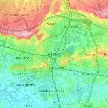
Naam: Topografische kaart Redhill, hoogte, reliëf.
Gemiddelde hoogte: 107 m
Minimale hoogte: 47 m
Maximale hoogte: 236 m
Andere topografische kaarten
Klik op een kaart om zijn topografie, zijn hoogte en zijn reliëf te bekijken.
Lower Earlswood Lake
United Kingdom > England > Surrey > Reigate and Banstead > Redhill
Gemiddelde hoogte: 75 m
Redhill Common
United Kingdom > England > Surrey > Reigate and Banstead > Redhill
Gemiddelde hoogte: 92 m
Banstead Wood
United Kingdom > England > Surrey > Reigate and Banstead > Chipstead
Gemiddelde hoogte: 145 m
Reigate Park
United Kingdom > England > Surrey > Reigate and Banstead > Reigate
Gemiddelde hoogte: 80 m
Horley
United Kingdom > England > Surrey > Reigate and Banstead
Horley is at an altitude of around 54 m (177 ft) above mean sea level.
Gemiddelde hoogte: 58 m