
Topografische kaart Mount Abu
Interactieve kaart
Klik op de kaart om de hoogte weer te geven.
Over deze kaart
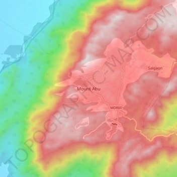
Naam: Topografische kaart Mount Abu, hoogte, reliëf.
Gemiddelde hoogte: 914 m
Minimale hoogte: 279 m
Maximale hoogte: 1.422 m
Mount Abu town, the only hill station in Rajasthan, is at an elevation of 1,220 m (4,003 ft). It has been a popular retreat from the heat of Rajasthan and neighboring Gujarat for centuries.
Andere topografische kaarten
Klik op een kaart om zijn topografie, zijn hoogte en zijn reliëf te bekijken.
Aravalli Range
India > Rajasthan > Abu Road Tehsil
Aravalli Range, Abu Road Tehsil, Sirohi District, Rajasthan, 307501, India
Gemiddelde hoogte: 1.339 m
Guru Shikhar, Abu
India > Rajasthan > Abu Road Tehsil
Guru Shikhar, Abu, Abu Road Tehsil, Sirohi District, Rajasthan, 307501, India
Gemiddelde hoogte: 1.366 m