
Topografische kaart Dover
Interactieve kaart
Klik op de kaart om de hoogte weer te geven.
Over deze kaart
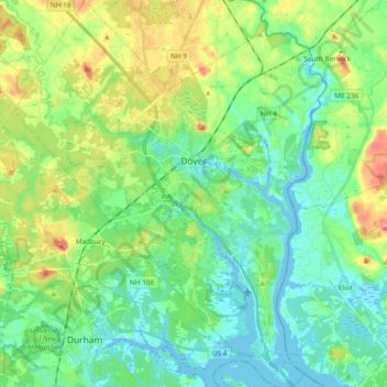
Naam: Topografische kaart Dover, hoogte, reliëf.
Locatie: Dover, Strafford County, New Hampshire, 03820, United States (43.11764 -70.96161 43.25498 -70.81902)
Gemiddelde hoogte: 31 m
Minimale hoogte: -9 m
Maximale hoogte: 106 m
According to the United States Census Bureau, the city has a total area of 29.0 square miles (75.2 km2), of which 26.7 square miles (69.2 km2) are land and 2.3 square miles (6.0 km2) are water, comprising 7.97% of the city. Dover is drained by the Cochecho and Bellamy rivers, both of which flow into the tidal Piscataqua River, which forms the city's eastern boundary and the New Hampshire–Maine border. Long Hill, elevation greater than 300 feet (91 m) above sea level and located 3 miles (5 km) northwest of the city center, is the highest point in Dover. Garrison Hill, elevation approximately 290 ft (88 m), is a prominent hill rising directly above the center city, with a park and lookout tower on top.
Andere topografische kaarten
Klik op een kaart om zijn topografie, zijn hoogte en zijn reliëf te bekijken.
Rollinsford
United States > New Hampshire > Strafford County
Rollinsford, Strafford County, New Hampshire, 03869, United States
Gemiddelde hoogte: 32 m
Somersworth
United States > New Hampshire > Strafford County
Somersworth, Strafford County, New Hampshire, 03878, United States
Gemiddelde hoogte: 56 m
New Durham
United States > New Hampshire > Strafford County
New Durham, Strafford County, New Hampshire, 03855, United States
Gemiddelde hoogte: 228 m
Dover
United States > New Hampshire > Strafford County > Dover
Dover, Strafford County, New Hampshire, 03820, United States
Gemiddelde hoogte: 52 m
Lee
United States > New Hampshire > Strafford County
Lee, Strafford County, New Hampshire, 03861, United States
Gemiddelde hoogte: 47 m
Rochester
United States > New Hampshire > Strafford County > Rochester
Rochester, Strafford County, New Hampshire, United States
Gemiddelde hoogte: 90 m