Geolokaliseren
👉 Easily get elevation data in JSON, GeoTIFF and KML formats using Elevation API
Bedankt voor het steunen van deze site ❤️
Doe een donatie

Topografische kaart Gateshead

Klik op de kaart om de hoogte weer te geven.

👉 Easily get elevation data in JSON, GeoTIFF and KML formats using Elevation API
Bedankt voor het steunen van deze site ❤️
Doe een donatie

Gateshead

One of the most distinguishing features of Gateshead is its topography. The land rises 230 feet (70 m) from Gateshead Quays to the town centre and continues rising to a height of 525 feet (160 m) at Queen Elizabeth Hospital in Sheriff Hill. This is in contrast to the flat and low lying Team Valley located on the western edges of town. The high elevations allow for impressive views over the Tyne valley into Newcastle and across Tyneside to Sunderland and the North Sea from lookouts in Windmill Hills and Windy Nook respectively.

Wikipedia (CC-BY-SA 3.0)

Over deze kaart

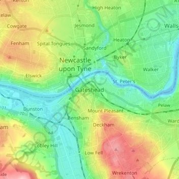
Naam: Topografische kaart Gateshead, hoogte, reliëf.

Locatie: Gateshead, Tyne and Wear, North East, England, NE8 1AG, United Kingdom (54.92258 -1.64193 55.00258 -1.56193)

Gemiddelde hoogte: 62 m

Minimale hoogte: -5 m

Maximale hoogte: 184 m

Rust jezelf uit voor je volgende avontuur:

🔭Telescopen - Bekijk de sterrenhemel vanaf een donkere bergtop
🧥Softshell Jassen - Ademende jassen voor actieve outdoor activiteiten
📦Waterdichte Tassen - Beschermt uitrusting tegen regen en water
📸Verrekijkers - Heldere optiek voor het spotten van wild en landschappen
💧Drinkflessen & Bidons - Duurzame en lekvrije flessen voor hydratatie

Als Amazon-partner verdient deze site een commissie op in aanmerking komende aankopen, zonder extra kosten voor jou.