
Topografische kaart Payneway
Interactieve kaart
Klik op de kaart om de hoogte weer te geven.
Over deze kaart
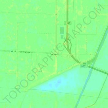
Naam: Topografische kaart Payneway, hoogte, reliëf.
Locatie: Payneway, Poinsett County, Arkansas, United States (35.52314 -90.52288 35.56314 -90.48288)
Gemiddelde hoogte: 65 m
Minimale hoogte: 57 m
Maximale hoogte: 68 m
Andere topografische kaarten
Klik op een kaart om zijn topografie, zijn hoogte en zijn reliëf te bekijken.
Harrisburg
United States > Arkansas > Poinsett County
Harrisburg, Poinsett County, Arkansas, United States
Gemiddelde hoogte: 95 m
Trumann
United States > Arkansas > Poinsett County
Trumann, Poinsett County, Arkansas, United States
Gemiddelde hoogte: 68 m
Dobell
United States > Arkansas > Poinsett County > Trumann
Dobell, Trumann, Poinsett County, Arkansas, 72472, United States
Gemiddelde hoogte: 68 m
Weiner
United States > Arkansas > Poinsett County
Weiner, Poinsett County, Arkansas, 72479, United States
Gemiddelde hoogte: 75 m
Trumann
United States > Arkansas > Poinsett County > Trumann > Trumann
Trumann, Poinsett County, Arkansas, 72472, United States
Gemiddelde hoogte: 67 m
Marked Tree
United States > Arkansas > Poinsett County
Marked Tree, Poinsett County, Arkansas, 72365, United States
Gemiddelde hoogte: 66 m
Tyronza
United States > Arkansas > Poinsett County > Tyronza
Tyronza, Poinsett County, Arkansas, United States
Gemiddelde hoogte: 67 m
Greenfield
United States > Arkansas > Poinsett County
Greenfield, Poinsett County, Arkansas, United States
Gemiddelde hoogte: 87 m
Fisher
United States > Arkansas > Poinsett County
Fisher, Poinsett County, Arkansas, United States
Gemiddelde hoogte: 70 m
Waldenburg
United States > Arkansas > Poinsett County > Waldenburg
Waldenburg, Poinsett County, Arkansas, 72475, United States
Gemiddelde hoogte: 73 m