
Topografische kaart Town of Sanborn
Interactieve kaart
Klik op de kaart om de hoogte weer te geven.
Over deze kaart
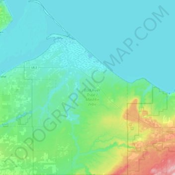
Naam: Topografische kaart Town of Sanborn, hoogte, reliëf.
Gemiddelde hoogte: 220 m
Minimale hoogte: 176 m
Maximale hoogte: 453 m
Andere topografische kaarten
Klik op een kaart om zijn topografie, zijn hoogte en zijn reliëf te bekijken.
Ashland
United States > Wisconsin > Ashland County
Ashland, Ashland County, Wisconsin, United States
Gemiddelde hoogte: 209 m
Glidden
United States > Wisconsin > Ashland County
Glidden, Town of Jacobs, Ashland County, Wisconsin, 54527, United States
Gemiddelde hoogte: 468 m
Mellen
United States > Wisconsin > Ashland County
Mellen, Ashland County, Wisconsin, 54546, United States
Gemiddelde hoogte: 395 m
Highbridge
United States > Wisconsin > Ashland County
Highbridge, Town of Ashland, Ashland County, Wisconsin, 54846, United States
Gemiddelde hoogte: 295 m
Clam Lake
United States > Wisconsin > Ashland County
Clam Lake, Town of Gordon, Ashland County, Wisconsin, United States
Gemiddelde hoogte: 441 m
La Pointe
United States > Wisconsin > Ashland County
La Pointe, Town of La Pointe, Ashland County, Wisconsin, 54580, United States
Gemiddelde hoogte: 186 m
Madeline Island
United States > Wisconsin > Ashland County > La Pointe
Madeline Island, La Pointe, Town of La Pointe, Ashland County, Wisconsin, 54580, United States
Gemiddelde hoogte: 187 m
Butternut
United States > Wisconsin > Ashland County
Butternut, Ashland County, Wisconsin, United States
Gemiddelde hoogte: 466 m
Marengo
United States > Wisconsin > Ashland County
Marengo, Town of White River, Ashland County, Wisconsin, 54855, United States
Gemiddelde hoogte: 240 m
Pictured Rock Lake
United States > Wisconsin > Ashland County
Pictured Rock Lake, Town of Sanborn, Ashland County, Wisconsin, United States
Gemiddelde hoogte: 199 m
Town of Chippewa
United States > Wisconsin > Ashland County
Town of Chippewa, Ashland County, Wisconsin, 54671, United States
Gemiddelde hoogte: 458 m