
Topografische kaart Ramganga Dam
Interactieve kaart
Klik op de kaart om de hoogte weer te geven.
Over deze kaart
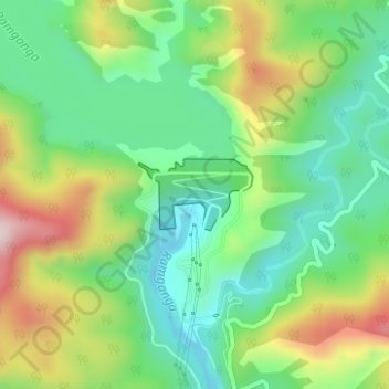
Naam: Topografische kaart Ramganga Dam, hoogte, reliëf.
Locatie: Ramganga Dam, Kotdwara, Pauri Garhwal, Uttarakhand, India (29.51557 78.75378 29.52048 78.76286)
Gemiddelde hoogte: 389 m
Minimale hoogte: 257 m
Maximale hoogte: 617 m
The dam is a 128 m (420 ft) tall and 630 m (2,067 ft) long earth and rock-fill embankment dam with 10,000,000 m3 (13,079,506 cu yd) of fill. The dam's spillway is controlled by five gates and has a maximum discharge of 8,467 m3/s (299,009 cu ft/s). To support the reservoir's elevation, there is a 72 m (236 ft) tall saddle dam on the reservoir's rim 2.5 km (2 mi) to the northeast on the Chui Sot River. The reservoir created by both dams has a 244,700,000 m3 (198,382 acre⋅ft) capacity of which 219,000,000 m3 (177,546 acre⋅ft) is active (or "useful") capacity. The reservoir has a surface of 78.31 km2 (30 sq mi) and a catchment area of 3,134 km2 (1,210 sq mi). The power station at the toe of the dam contains three 66 MW Francis turbine-generators and is afforded 84.4 m (277 ft) of design hydraulic head. Below the dam is a system of over 6,300 km (3,915 mi) of canals supported by three barrages and 82 km (51 mi) of main feeder canal.
Andere topografische kaarten
Klik op een kaart om zijn topografie, zijn hoogte en zijn reliëf te bekijken.
Kotdwar
India > Uttarakhand > Kotdwara
Kotdwar, Kotdwara, Pauri Garhwal District, Uttarakhand, 246149, India
Gemiddelde hoogte: 471 m
Dugadda
India > Uttarakhand > Kotdwara
Dugadda, Kotdwara, Pauri Garhwal District, Uttarakhand, India
Gemiddelde hoogte: 896 m