
Topografische kaart Wolcott
Interactieve kaart
Klik op de kaart om de hoogte weer te geven.
Over deze kaart
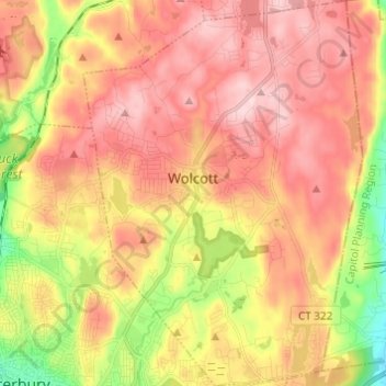
Naam: Topografische kaart Wolcott, hoogte, reliëf.
Gemiddelde hoogte: 209 m
Minimale hoogte: 56 m
Maximale hoogte: 320 m
The highest point in New Haven County is found in Wolcott atop Lindsley Hill, which has an elevation of approximately 1,046 feet above sea level.
Andere topografische kaarten
Klik op een kaart om zijn topografie, zijn hoogte en zijn reliëf te bekijken.
Southbury
United States > Connecticut > Naugatuck Valley COG
Southbury, Naugatuck Valley COG, Connecticut, 06488, United States
Gemiddelde hoogte: 144 m
Ansonia
United States > Connecticut > Naugatuck Valley COG
Ansonia, Naugatuck Valley COG, Connecticut, 06401, United States
Gemiddelde hoogte: 76 m
Forestville
United States > Connecticut > Naugatuck Valley COG > Bristol
Forestville, Bristol, Naugatuck Valley COG, Connecticut, 06010, United States
Gemiddelde hoogte: 99 m