
Topografische kaart Supai
Interactieve kaart
Klik op de kaart om de hoogte weer te geven.
Over deze kaart
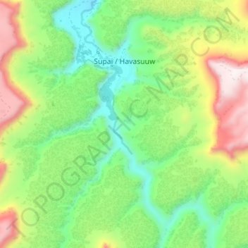
Naam: Topografische kaart Supai, hoogte, reliëf.
Locatie: Supai, Coconino County, Arizona, United States (36.19783 -112.70754 36.24934 -112.67665)
Gemiddelde hoogte: 1.263 m
Minimale hoogte: 927 m
Maximale hoogte: 1.806 m
Supai can be reached by hiking 8 miles (13 km), descending 2,004 feet (611 m) in elevation from Hualapai Hilltop through the Hualapai Canyon. Alternatively, the AirWest Helicopters service schedules flights from Hualapai Hilltop to Supai. Hualapai Hilltop is located about 70 miles (110 km) from the community of Peach Springs, along paved BIA Road 18.