
Topografische kaart Santa María de la Alameda
Interactieve kaart
Klik op de kaart om de hoogte weer te geven.
Over deze kaart
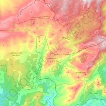
Naam: Topografische kaart Santa María de la Alameda, hoogte, reliëf.
Gemiddelde hoogte: 1.339 m
Minimale hoogte: 872 m
Maximale hoogte: 1.783 m
Originally a group of cattle-raising hamlets, the municipality comprises different settlements: Las Herreras, El Pimpollar, La Hoya, Navalespino, La Paradilla, Robledondo, Santa María de la Alameda and Santa María Estación. In time, the nucleus of "Santa María Estación", developed around the railway station, has grown to become the most populated settlement. The capital of the municipality (the namesake "Santa María de la Alameda") is located at an elevation of 1,409 metres. The municipality covers an area of 74.41 km2, including the exclave of Dehesa de la Cepeda, a mostly pasture area geographically located between the provinces of Ávila and Segovia in the autonomous community of Castile and León.
Andere topografische kaarten
Klik op een kaart om zijn topografie, zijn hoogte en zijn reliëf te bekijken.
Navalagamella
Spain > Community of Madrid > Sierra Oeste
Navalagamella, Sierra Oeste, Community of Madrid, 28212, Spain
Gemiddelde hoogte: 718 m