
Topografische kaart Jonesville
Interactieve kaart
Klik op de kaart om de hoogte weer te geven.
Over deze kaart
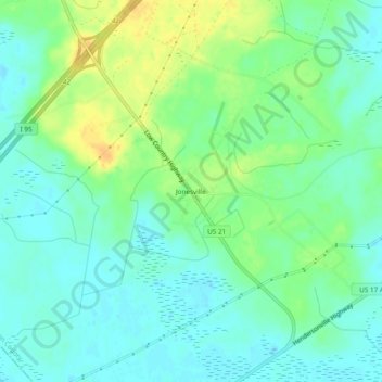
Naam: Topografische kaart Jonesville, hoogte, reliëf.
Locatie: Jonesville, Colleton County, South Carolina, United States (32.71629 -80.83594 32.75629 -80.79594)
Gemiddelde hoogte: 11 m
Minimale hoogte: 0 m
Maximale hoogte: 28 m
Andere topografische kaarten
Klik op een kaart om zijn topografie, zijn hoogte en zijn reliëf te bekijken.
Islandton
United States > South Carolina > Colleton County
Islandton, Colleton County, South Carolina, 29929, United States
Gemiddelde hoogte: 21 m
Red Oak Corner
United States > South Carolina > Colleton County
Red Oak Corner, Colleton County, South Carolina, 29435, United States
Gemiddelde hoogte: 13 m
Round O
United States > South Carolina > Colleton County
Round O, Colleton County, South Carolina, 29474, United States
Gemiddelde hoogte: 11 m
Edisto Beach
United States > South Carolina > Colleton County > Edisto Beach
Edisto Beach, Colleton County, South Carolina, United States
Gemiddelde hoogte: 3 m