
Topografische kaart Spring Gap Mountain
Interactieve kaart
Klik op de kaart om de hoogte weer te geven.
Over deze kaart
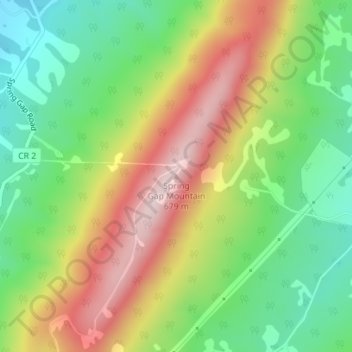
Naam: Topografische kaart Spring Gap Mountain, hoogte, reliëf.
Gemiddelde hoogte: 468 m
Minimale hoogte: 315 m
Maximale hoogte: 665 m
Spring Gap Mountain runs southwest northeast through Morgan and Hampshire counties in West Virginia's Eastern Panhandle, rising to its greatest elevation of 2,237 ft (682 m) north of "Spring Gap", from which the mountain takes its name. The gap is the source for Dug Hill Run, a tributary stream of the Little Cacapon River.
Andere topografische kaarten
Klik op een kaart om zijn topografie, zijn hoogte en zijn reliëf te bekijken.
Augusta
United States > West Virginia > Hampshire County
Augusta, Hampshire County, West Virginia, 26704, United States
Gemiddelde hoogte: 380 m
Hooks Mills
United States > West Virginia > Hampshire County
Hooks Mills, Hampshire County, West Virginia, 26808, United States
Gemiddelde hoogte: 327 m
Cacapon River
United States > West Virginia > Hampshire County
Cacapon River, Hampshire County, West Virginia, United States
Gemiddelde hoogte: 326 m
Nathaniel Mountain
United States > West Virginia > Hampshire County
Nathaniel Mountain, Hampshire County, West Virginia, United States
Gemiddelde hoogte: 687 m
Romney
United States > West Virginia > Hampshire County
Romney, Hampshire County, West Virginia, 26757, United States
Gemiddelde hoogte: 249 m
Levels
United States > West Virginia > Hampshire County > Levels
Levels, Hampshire County, West Virginia, 25431, United States
Gemiddelde hoogte: 312 m
Sector
United States > West Virginia > Hampshire County
Sector, Hampshire County, West Virginia, United States
Gemiddelde hoogte: 337 m