
Topografische kaart Fuente de San Esteban
Interactieve kaart
Klik op de kaart om de hoogte weer te geven.
Over deze kaart
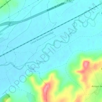
Naam: Topografische kaart Fuente de San Esteban, hoogte, reliëf.
Gemiddelde hoogte: 811 m
Minimale hoogte: 791 m
Maximale hoogte: 897 m
Andere topografische kaarten
Klik op een kaart om zijn topografie, zijn hoogte en zijn reliëf te bekijken.
Mazuelo de Muñó
España > Castilla y León > Estépar
Mazuelo de Muñó, Estépar, Burgos, Castilla y León, 09239, España
Gemiddelde hoogte: 860 m
Arroyo de Muñó
España > Castilla y León > Estépar > Arroyo de Muñó
Arroyo de Muñó, Estépar, Burgos, Castilla y León, 09239, España
Gemiddelde hoogte: 841 m
Estépar
España > Castilla y León > Estépar
Estépar, Burgos, Castilla y León, España
Gemiddelde hoogte: 860 m