
Topografische kaart Austinville
Interactieve kaart
Klik op de kaart om de hoogte weer te geven.
Over deze kaart
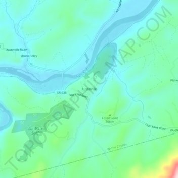
Naam: Topografische kaart Austinville, hoogte, reliëf.
Locatie: Austinville, Wythe County, Virginia, 24312, United States (36.83123 -80.93202 36.87123 -80.89202)
Gemiddelde hoogte: 645 m
Minimale hoogte: 585 m
Maximale hoogte: 896 m
Andere topografische kaarten
Klik op een kaart om zijn topografie, zijn hoogte en zijn reliëf te bekijken.
Ivanhoe
United States > Virginia > Wythe County
Ivanhoe, Wythe County, Virginia, 24350, United States
Gemiddelde hoogte: 643 m
Cripple Creek
United States > Virginia > Wythe County > Speedwell
Cripple Creek, Speedwell, Wythe County, Virginia, 24374, United States
Gemiddelde hoogte: 733 m
Wytheville
United States > Virginia > Wythe County
Wytheville, Wythe County, Virginia, 24382, United States
Gemiddelde hoogte: 720 m
Barren Springs
United States > Virginia > Wythe County
Barren Springs, Wythe County, Virginia, 24313, United States
Gemiddelde hoogte: 642 m
Max Meadows
United States > Virginia > Wythe County
Max Meadows, Wythe County, Virginia, United States
Gemiddelde hoogte: 662 m
Stones Mill
United States > Virginia > Wythe County > Wytheville > Stones Mill
Stones Mill, Wytheville, Wythe County, Virginia, 24382, United States
Gemiddelde hoogte: 710 m