
Topografische kaart Bald Peak
Interactieve kaart
Klik op de kaart om de hoogte weer te geven.
Over deze kaart
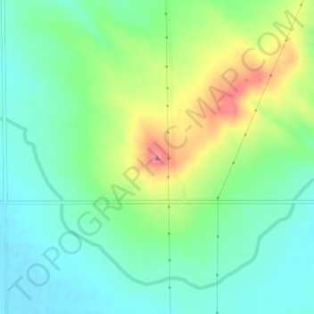
Naam: Topografische kaart Bald Peak, hoogte, reliëf.
Locatie: Bald Peak, Scotts Bluff County, Nebraska, United States (41.87520 -103.91055 41.87530 -103.91045)
Gemiddelde hoogte: 1.293 m
Minimale hoogte: 1.264 m
Maximale hoogte: 1.349 m
Andere topografische kaarten
Klik op een kaart om zijn topografie, zijn hoogte en zijn reliëf te bekijken.
Terrytown
United States > Nebraska > Scotts Bluff County
Terrytown, Scotts Bluff County, Nebraska, United States
Gemiddelde hoogte: 1.186 m
Mitchell
United States > Nebraska > Scotts Bluff County
Mitchell, Scotts Bluff County, Nebraska, United States
Gemiddelde hoogte: 1.209 m
Scottsbluff
United States > Nebraska > Scotts Bluff County
Scottsbluff, Scotts Bluff County, Nebraska, 69361, United States
Gemiddelde hoogte: 1.190 m
Scottsbluff
United States > Nebraska > Scotts Bluff County > Scottsbluff
Scottsbluff, Scotts Bluff County, Nebraska, 69361, United States
Gemiddelde hoogte: 1.259 m
Melbeta
United States > Nebraska > Scotts Bluff County > Melbeta
Melbeta, Scotts Bluff County, Nebraska, United States
Gemiddelde hoogte: 1.166 m
Gering
United States > Nebraska > Scotts Bluff County > Gering
Gering, Scotts Bluff County, Nebraska, United States
Gemiddelde hoogte: 1.195 m