
Topografische kaart Colfax
Interactieve kaart
Klik op de kaart om de hoogte weer te geven.
Over deze kaart
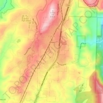
Naam: Topografische kaart Colfax, hoogte, reliëf.
Locatie: Colfax, Placer County, California, United States (39.07492 -120.96506 39.11484 -120.93491)
Gemiddelde hoogte: 685 m
Minimale hoogte: 442 m
Maximale hoogte: 860 m
Colfax has a hot-summer Mediterranean climate (Köppen Csa) that is characterized by cool, wet winters and hot, dry summers. Summers can be quite hot, especially in the months of July and August where temperatures easily reach 90 °F (32 °C), with plenty of sunshine. Winters, on the other hand, are quite cool with temperatures in December hovering around 46 °F (8 °C), and owing to its altitude above sea level, Colfax some years sees snow accumulation.
Andere topografische kaarten
Klik op een kaart om zijn topografie, zijn hoogte en zijn reliëf te bekijken.
Big Chief
United States > California > Placer County
Big Chief, Placer County, California, 96146, United States
Gemiddelde hoogte: 2.035 m
Roseville
United States > California > Placer County
Roseville, Placer County, CAL Fire Northern Region, California, United States
Gemiddelde hoogte: 61 m
Auburn
United States > California > Placer County
Auburn, Placer County, California, 95603, United States
Gemiddelde hoogte: 380 m
Foresthill
United States > California > Placer County
Foresthill, Placer County, California, 95631, United States
Gemiddelde hoogte: 749 m
Rocklin
United States > California > Placer County
Rocklin, Placer County, California, United States
Gemiddelde hoogte: 95 m
Salmon Lake
United States > California > Placer County
Salmon Lake, Placer County, California, United States
Gemiddelde hoogte: 2.023 m
Kings Beach
United States > California > Placer County > Kings Beach
Kings Beach, Placer County, California, 93143, United States
Gemiddelde hoogte: 1.955 m
Lake Tahoe
United States > California > Placer County
Lake Tahoe, Placer County, California, United States
Gemiddelde hoogte: 2.077 m