
Topografische kaart Chisholm
Interactieve kaart
Klik op de kaart om de hoogte weer te geven.
Over deze kaart
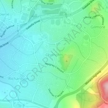
Naam: Topografische kaart Chisholm, hoogte, reliëf.
Gemiddelde hoogte: 642 m
Minimale hoogte: 598 m
Maximale hoogte: 789 m
Andere topografische kaarten
Klik op een kaart om zijn topografie, zijn hoogte en zijn reliëf te bekijken.
Urambi Hills Nature Reserve
Australia > District of Tuggeranong
Urambi Hills Nature Reserve, Kambah, District of Tuggeranong, Australian Capital Territory, 2902, Australia
Gemiddelde hoogte: 596 m
Kambah
Australia > District of Tuggeranong
Kambah, District of Tuggeranong, Australian Capital Territory, 2902, Australia
Gemiddelde hoogte: 622 m
Conder
Australia > District of Tuggeranong
Conder, District of Tuggeranong, Australian Capital Territory, 2906, Australia
Gemiddelde hoogte: 658 m
Wanniassa
Australia > District of Tuggeranong
Wanniassa, District of Tuggeranong, Australian Capital Territory, 2903, Australia
Gemiddelde hoogte: 623 m
Mount Taylor
Australia > District of Tuggeranong
Mount Taylor, District of Tuggeranong, Australian Capital Territory, 2902, Australia
Gemiddelde hoogte: 660 m
Calwell
Australia > District of Tuggeranong
Calwell, District of Tuggeranong, Australian Capital Territory, Australia
Gemiddelde hoogte: 648 m
Fadden
Australia > District of Tuggeranong
Fadden, District of Tuggeranong, Australian Capital Territory, Australia
Gemiddelde hoogte: 663 m
Greenway
Australia > District of Tuggeranong
Greenway, District of Tuggeranong, Australian Capital Territory, 2900, Australia
Gemiddelde hoogte: 583 m
Gordon
Australia > District of Tuggeranong
Gordon, District of Tuggeranong, Australian Capital Territory, Australia
Gemiddelde hoogte: 610 m
Monash
Australia > District of Tuggeranong
Monash, District of Tuggeranong, Australian Capital Territory, Australia
Gemiddelde hoogte: 597 m
Theodore
Australia > District of Tuggeranong
Theodore, District of Tuggeranong, Australian Capital Territory, Australia
Gemiddelde hoogte: 686 m