
Topografische kaart Deer Park
Interactieve kaart
Klik op de kaart om de hoogte weer te geven.
Over deze kaart
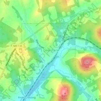
Naam: Topografische kaart Deer Park, hoogte, reliëf.
Locatie: Deer Park, Garrett County, Maryland, United States (39.41677 -79.33516 39.43126 -79.31656)
Gemiddelde hoogte: 774 m
Minimale hoogte: 737 m
Maximale hoogte: 834 m
Andere topografische kaarten
Klik op een kaart om zijn topografie, zijn hoogte en zijn reliëf te bekijken.
Swanton
United States > Maryland > Garrett County
Swanton, Garrett County, Maryland, 21561, United States
Gemiddelde hoogte: 789 m
Shallmar
United States > Maryland > Garrett County
Shallmar, Garrett County, Maryland, 21538, United States
Gemiddelde hoogte: 653 m
Loch Lynn Heights
United States > Maryland > Garrett County
Loch Lynn Heights, Garrett County, Maryland, United States
Gemiddelde hoogte: 747 m
Redhouse
United States > Maryland > Garrett County
Redhouse, Garrett County, Maryland, United States
Gemiddelde hoogte: 777 m
Deep Creek Lake
United States > Maryland > Garrett County > McHenry
Deep Creek Lake, McHenry, Garrett County, Maryland, 21541, United States
Gemiddelde hoogte: 793 m
Mountain Lake Park
United States > Maryland > Garrett County
Mountain Lake Park, Garrett County, Maryland, United States
Gemiddelde hoogte: 749 m
Finzel
United States > Maryland > Garrett County > Finzel
Finzel, Garrett County, Maryland, United States
Gemiddelde hoogte: 778 m
McHenry
United States > Maryland > Garrett County
McHenry, Garrett County, Maryland, 21541, United States
Gemiddelde hoogte: 817 m
Selbysport
United States > Maryland > Garrett County
Selbysport, Garrett County, Maryland, 21531, United States
Gemiddelde hoogte: 553 m
Accident
United States > Maryland > Garrett County
Accident, Garrett County, Maryland, United States
Gemiddelde hoogte: 751 m
Friendsville
United States > Maryland > Garrett County
Friendsville, Garrett County, Maryland, United States
Gemiddelde hoogte: 528 m
Oakland
United States > Maryland > Garrett County
Oakland, Garrett County, Maryland, United States
Gemiddelde hoogte: 763 m
Meadow Mountain
United States > Maryland > Garrett County
Meadow Mountain, Garrett County, Maryland, 21522, United States
Gemiddelde hoogte: 798 m
Bloomington
United States > Maryland > Garrett County > Bloomington
Bloomington, Garrett County, Maryland, 21523, United States
Gemiddelde hoogte: 405 m
Kitzmiller
United States > Maryland > Garrett County
Kitzmiller, Garrett County, Maryland, United States
Gemiddelde hoogte: 604 m
Swanton
United States > Maryland > Garrett County > Swanton
Swanton, Garrett County, Maryland, United States
Gemiddelde hoogte: 773 m
Hoyes Run
United States > Maryland > Garrett County > Hoyes Run
Hoyes Run, Garrett County, Maryland, United States
Gemiddelde hoogte: 756 m
Bloomington
United States > Maryland > Garrett County
Bloomington, Garrett County, Maryland, 21523, United States
Gemiddelde hoogte: 436 m
Grantsville
United States > Maryland > Garrett County
Grantsville, Garrett County, Maryland, United States
Gemiddelde hoogte: 706 m
Savage River
United States > Maryland > Garrett County > Bloomington
Savage River, Bloomington, Garrett County, Maryland, 21523, United States
Gemiddelde hoogte: 687 m