
Topografische kaart St. Catharines
Klik op de kaart om de hoogte weer te geven.
St. Catharines
The most defining transportation icon of St. Catharines is the Welland Canal, a ship canal that runs 43.4 kilometres (27.0 mi), passing through the city. Four of its locks are within city boundaries. The canal allows shipping vessels to traverse the 99.5-metre (326.5 ft) drop in altitude from Lake Erie to Lake Ontario.
Over deze kaart
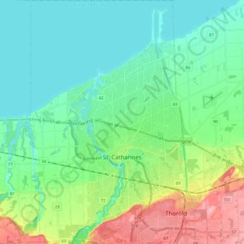
Naam: Topografische kaart St. Catharines, hoogte, reliëf.
Gemiddelde hoogte: 103 m
Minimale hoogte: 70 m
Maximale hoogte: 195 m
Andere topografische kaarten
Klik op een kaart om zijn topografie, zijn hoogte en zijn reliëf te bekijken.
Queenston Heights Park
Canada > Ontario > Niagara Region > Niagara-on-the-Lake > Queenston
Gemiddelde hoogte: 139 m
Wainfleet Lake Erie Public Access Beach
Canada > Ontario > Niagara Region > Wainfleet
Gemiddelde hoogte: 175 m