
Topografische kaart Mukilteo
Interactieve kaart
Klik op de kaart om de hoogte weer te geven.
Over deze kaart
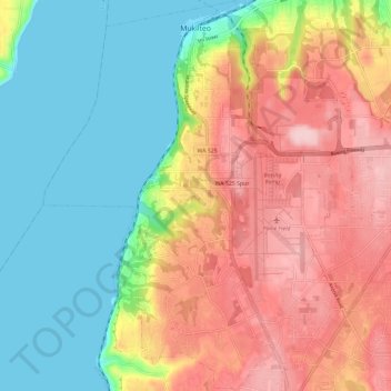
Naam: Topografische kaart Mukilteo, hoogte, reliëf.
Gemiddelde hoogte: 89 m
Minimale hoogte: -1 m
Maximale hoogte: 200 m
Andere topografische kaarten
Klik op een kaart om zijn topografie, zijn hoogte en zijn reliëf te bekijken.
Everett
United States > Washington > Snohomish County
Everett, Snohomish County, Washington, United States
Gemiddelde hoogte: 66 m
Lynnwood
United States > Washington > Snohomish County
Lynnwood, Snohomish County, Washington, 98037, United States
Gemiddelde hoogte: 121 m
Granite Falls
United States > Washington > Snohomish County
Granite Falls, Snohomish County, Washington, United States
Gemiddelde hoogte: 120 m
Mill Creek
United States > Washington > Snohomish County
Mill Creek, Snohomish County, Washington, United States
Gemiddelde hoogte: 130 m
Everett
United States > Washington > Snohomish County > Everett
Everett, Snohomish County, Washington, 98120, United States
Gemiddelde hoogte: 67 m
Marysville
United States > Washington > Snohomish County
Marysville, Snohomish County, Washington, United States
Gemiddelde hoogte: 72 m