
Topografische kaart St. Georges Channel
Interactieve kaart
Klik op de kaart om de hoogte weer te geven.
Over deze kaart
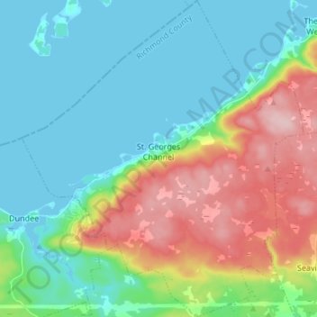
Naam: Topografische kaart St. Georges Channel, hoogte, reliëf.
Gemiddelde hoogte: 60 m
Minimale hoogte: -3 m
Maximale hoogte: 199 m
Andere topografische kaarten
Klik op een kaart om zijn topografie, zijn hoogte en zijn reliëf te bekijken.
Cleveland
Kanada > Neuschottland > Municipality of the County of Richmond
Cleveland, Municipality of the County of Richmond, Richmond County, Neuschottland, Kanada
Gemiddelde hoogte: 40 m