
Topografische kaart Robinson
Interactieve kaart
Klik op de kaart om de hoogte weer te geven.
Over deze kaart
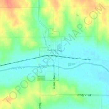
Naam: Topografische kaart Robinson, hoogte, reliëf.
Locatie: Robinson, Brown County, Kansas, United States (39.80907 -95.41599 39.82202 -95.40715)
Gemiddelde hoogte: 305 m
Minimale hoogte: 286 m
Maximale hoogte: 335 m
Andere topografische kaarten
Klik op een kaart om zijn topografie, zijn hoogte en zijn reliëf te bekijken.
Everest
United States > Kansas > Brown County
Everest, Brown County, Kansas, United States
Gemiddelde hoogte: 346 m
Fairview
United States > Kansas > Brown County
Fairview, Brown County, Kansas, United States
Gemiddelde hoogte: 368 m
Morrill
United States > Kansas > Brown County
Morrill, Brown County, Kansas, United States
Gemiddelde hoogte: 341 m
Horton
United States > Kansas > Brown County
Horton, Brown County, Kansas, United States
Gemiddelde hoogte: 327 m
Powhattan
United States > Kansas > Brown County
Powhattan, Brown County, Kansas, United States
Gemiddelde hoogte: 361 m
Hamlin
United States > Kansas > Brown County
Hamlin, Brown County, Kansas, United States
Gemiddelde hoogte: 315 m
Willis
United States > Kansas > Brown County
Willis, Brown County, Kansas, United States
Gemiddelde hoogte: 349 m
Reserve
United States > Kansas > Brown County
Reserve, Brown County, Kansas, United States
Gemiddelde hoogte: 286 m
Hiawatha
United States > Kansas > Brown County
Hiawatha, Brown County, Kansas, 66434, United States
Gemiddelde hoogte: 337 m