
Topografische kaart Emalahleni Ward 14
Interactieve kaart
Klik op de kaart om de hoogte weer te geven.
Over deze kaart
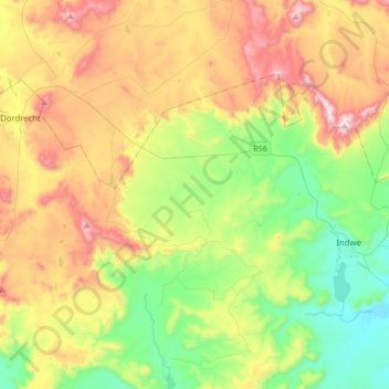
Naam: Topografische kaart Emalahleni Ward 14, hoogte, reliëf.
Gemiddelde hoogte: 1.560 m
Minimale hoogte: 1.211 m
Maximale hoogte: 2.109 m
Andere topografische kaarten
Klik op een kaart om zijn topografie, zijn hoogte en zijn reliëf te bekijken.
Xonxa Dam
RSA > Eastern Cape > Emalahleni Local Municipality
Xonxa Dam, Emalahleni Ward 1, Emalahleni Local Municipality, Chris Hani District Municipality, Eastern Cape, RSA
Gemiddelde hoogte: 1.037 m
Ntabankulu
RSA > Eastern Cape > Emalahleni Local Municipality
Ntabankulu, Emalahleni Local Municipality, Chris Hani District Municipality, Eastern Cape, RSA
Gemiddelde hoogte: 1.090 m
Emalahleni Ward 2
RSA > Eastern Cape > Emalahleni Local Municipality
Emalahleni Ward 2, Emalahleni Local Municipality, Chris Hani District Municipality, Eastern Cape, RSA
Gemiddelde hoogte: 1.080 m