
Topografische kaart Orcas Island
Interactieve kaart
Klik op de kaart om de hoogte weer te geven.
Orcas Island
Mount Constitution (elevation 2409 feet/734 meters) is the highest point in the San Juan islands. The mountain is part of Moran State Park, the largest public recreation area in the San Juan Islands, and the largest State Park in Washington. Moran State Park encompasses over 5,000 acres (2,000 ha) of woodland and has several lakes, including Cascade Lake, Mountain Lake, Summit Lake, and Twin Lakes, and numerous waterfalls.
Over deze kaart
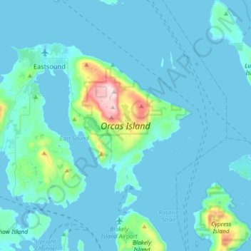
Naam: Topografische kaart Orcas Island, hoogte, reliëf.
Gemiddelde hoogte: 59 m
Minimale hoogte: -1 m
Maximale hoogte: 723 m