
Topografische kaart Mattupetty
Interactieve kaart
Klik op de kaart om de hoogte weer te geven.
Over deze kaart
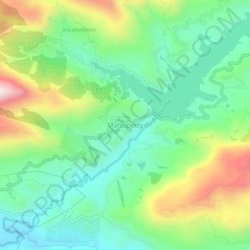
Naam: Topografische kaart Mattupetty, hoogte, reliëf.
Locatie: Mattupetty, Devikulam, Idukki District, Kerala, 685616, India (10.08485 77.09873 10.12485 77.13873)
Gemiddelde hoogte: 1.694 m
Minimale hoogte: 1.482 m
Maximale hoogte: 2.113 m
Andere topografische kaarten
Klik op een kaart om zijn topografie, zijn hoogte en zijn reliëf te bekijken.
Kottakombur
Kottakombur, Devikulam, Idukki District, Kerala, India
Gemiddelde hoogte: 1.919 m
Manna Malai
Manna Malai, Devikulam, Idukki District, Kerala, India
Gemiddelde hoogte: 2.235 m
Kallarkutty
Kallarkutty, Devikulam, Idukki District, Kerala, 685562, India
Gemiddelde hoogte: 571 m
Kunchithanny
India > Kerala > Devikulam > Anachal
Kunchithanny, Anachal, Devikulam, Idukki District, Kerala, India
Gemiddelde hoogte: 936 m