Topografische kaart Cossall
Interactieve kaart
Klik op de kaart om de hoogte weer te geven.
Over deze kaart
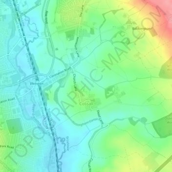
Naam: Topografische kaart Cossall, hoogte, reliëf.
Locatie: Cossall, Broxtowe, Nottinghamshire, England, United Kingdom (52.96638 -1.29747 52.98965 -1.25252)
Gemiddelde hoogte: 70 m
Minimale hoogte: 43 m
Maximale hoogte: 137 m
Andere topografische kaarten
Klik op een kaart om zijn topografie, zijn hoogte en zijn reliëf te bekijken.
Beeston
United Kingdom > England > Nottinghamshire > Broxtowe
Beeston, Broxtowe, Nottinghamshire, England, NG9 2JJ, United Kingdom
Gemiddelde hoogte: 44 m
Manor House Pond
United Kingdom > England > Nottinghamshire > Broxtowe > Bramcote
Manor House Pond, Bramcote Hills, Bramcote, Broxtowe, Nottinghamshire, England, United Kingdom
Gemiddelde hoogte: 57 m
Beeston
United Kingdom > England > Nottinghamshire > Broxtowe
Beeston, Broxtowe, Nottinghamshire, England, United Kingdom
Gemiddelde hoogte: 39 m
Nottingham Canal
United Kingdom > England > Nottinghamshire > Broxtowe
Nottingham Canal, Cossall Marsh, Broxtowe, Nottinghamshire, England, NG16 2RU, United Kingdom
Gemiddelde hoogte: 68 m
Attenborough Nature Reserve
United Kingdom > England > Nottinghamshire > Broxtowe
Attenborough Nature Reserve, Tissington Close, Chilwell Meadows Business Park, Chilwell, Broxtowe, Nottinghamshire, England, NG9 6QG, United Kingdom
Gemiddelde hoogte: 34 m
Kimberley
United Kingdom > England > Nottinghamshire > Broxtowe
Kimberley, Broxtowe, Nottinghamshire, England, United Kingdom
Gemiddelde hoogte: 104 m
Strelley
United Kingdom > England > Nottinghamshire > Broxtowe > Strelley
Strelley, Broxtowe, Nottinghamshire, East Midlands, England, United Kingdom
Gemiddelde hoogte: 100 m
Nuthall
United Kingdom > England > Nottinghamshire > Broxtowe
Nuthall, Broxtowe, Nottinghamshire, England, United Kingdom
Gemiddelde hoogte: 95 m
Nottingham Canal Local Nature Reserve
United Kingdom > England > Nottinghamshire > Broxtowe
Nottingham Canal Local Nature Reserve, Moor Lane, Bramcote Hills, Broxtowe, Nottinghamshire, East Midlands, England, NG9 3GP, United Kingdom
Gemiddelde hoogte: 66 m
Stapleford
United Kingdom > England > Nottinghamshire > Broxtowe
Stapleford, Broxtowe, Nottinghamshire, England, United Kingdom
Gemiddelde hoogte: 55 m
Giltbrook
United Kingdom > England > Nottinghamshire > Broxtowe
Giltbrook, Broxtowe, Nottinghamshire, England, NG16 2WJ, United Kingdom
Gemiddelde hoogte: 86 m
Stapleford
United Kingdom > England > Nottinghamshire > Broxtowe
Stapleford, Broxtowe, Nottinghamshire, England, United Kingdom
Gemiddelde hoogte: 54 m
Greasley
United Kingdom > England > Nottinghamshire > Broxtowe
Greasley, Broxtowe, Nottinghamshire, England, United Kingdom
Gemiddelde hoogte: 104 m
Eastwood CP
United Kingdom > England > Nottinghamshire > Broxtowe
Eastwood CP, Broxtowe, Nottinghamshire, England, United Kingdom
Gemiddelde hoogte: 81 m
Newthorpe
United Kingdom > England > Nottinghamshire > Broxtowe
Newthorpe, Broxtowe, Nottinghamshire, England, NG16 2AS, United Kingdom
Gemiddelde hoogte: 85 m