
Topografische kaart Holly Springs
Interactieve kaart
Klik op de kaart om de hoogte weer te geven.
Over deze kaart
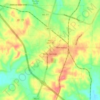
Naam: Topografische kaart Holly Springs, hoogte, reliëf.
Locatie: Holly Springs, Marshall County, Mississippi, United States (34.73934 -89.49547 34.80115 -89.41185)
Gemiddelde hoogte: 164 m
Minimale hoogte: 130 m
Maximale hoogte: 200 m
Andere topografische kaarten
Klik op een kaart om zijn topografie, zijn hoogte en zijn reliëf te bekijken.
Wall Doxey State Park
United States > Mississippi > Marshall County
Wall Doxey State Park, Marshall County, Mississippi, United States
Gemiddelde hoogte: 131 m
Byhalia
United States > Mississippi > Marshall County
Byhalia, Marshall County, Mississippi, 38611, United States
Gemiddelde hoogte: 111 m
Victoria
United States > Mississippi > Marshall County > Victoria
Victoria, Marshall County, Mississippi, 38679, United States
Gemiddelde hoogte: 133 m