
Topografische kaart Rosarito
Interactieve kaart
Klik op de kaart om de hoogte weer te geven.
Rosarito
Playas de Rosarito lies on the coast of the Pacific Ocean on the North Baja California Peninsula. The city is positioned between the foothills of the Peninsular Ranges and the ocean. It maintains a relatively uniform topography and displays few variances in terrain.
Over deze kaart
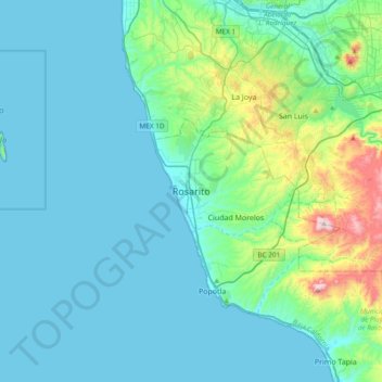
Naam: Topografische kaart Rosarito, hoogte, reliëf.
Gemiddelde hoogte: 103 m
Minimale hoogte: 0 m
Maximale hoogte: 724 m