
Topografische kaart Franklin
Interactieve kaart
Klik op de kaart om de hoogte weer te geven.
Franklin
According to the United States Census Bureau, the city has a total area of 29.2 square miles (75.5 km2), of which 27.5 square miles (71.1 km2) are land and 1.7 square miles (4.5 km2) are water, comprising 5.95% of the town. It is drained by the Winnipesaukee, Pemigewasset and Merrimack rivers. Webster Lake is in the north. The highest point in Franklin is an unnamed summit near the northwestern corner of the city limits, where the elevation reaches approximately 1,370 feet (420 m) above sea level. Franklin lies fully within the Merrimack River watershed.
Over deze kaart
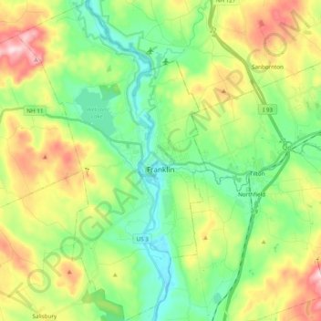
Naam: Topografische kaart Franklin, hoogte, reliëf.
Gemiddelde hoogte: 201 m
Minimale hoogte: 76 m
Maximale hoogte: 431 m
Andere topografische kaarten
Klik op een kaart om zijn topografie, zijn hoogte en zijn reliëf te bekijken.
Rings Corner
United States > New Hampshire > Merrimack County > Pittsfield > Rings Corner
Gemiddelde hoogte: 190 m